A. Weather and Climate
Where is weather created?
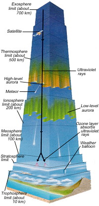 |
| Layers of
the atmosphere From "Ultimate Visual Dictionary of Science," Stoddart 1998. |
The troposphere is the layer of the atmosphere that is closest to Earth. It is approximately 10 kilometers in depth, where it meets the stratosphere.
Each layer is identified according to its variations in temperature compared to height. For example, in the troposphere, the temperature decreases with height, and in the stratosphere the temperature increases with height.
The whole atmosphere, from the troposphere to the exosphere, is only 700 kilometers deep.
This mixture of colorless, tasteless, odorless gases is the only thing that makes the earth an excellent environment for life. Without it, we could not live here any more than we could on Mars or the Moon. The atmosphere is the source of the air we breathe, the warmth we feel, the protection we have from the sun's harmful radiation, the water we drink and our protection from meteorites.
How is weather created?
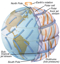 |
| Earth's wind
patterns From "Ultimate Visual Dictionary of Science," Stoddart 1998. |
It is more intense at the equator and gradually less so towards each of the poles, where it is coldest.
The difference in the temperatures in the various regions between the equator and each of the poles means that the air is warmer and colder to varying degrees around the Earth. Since warm air rises and cold air sinks, there are differences in air pressure in the troposphere, which causes continuous motion of the air. The movement of the air causes the constantly changing weather patterns on the Earth.
The constantly moving air is actually the source of winds around the world. Hot air rises at the equator and falls at the poles where it is the coldest (receiving less of the sun's warmth). There are three different zones of circulating air between the equator and each pole. Within each of these zones, the air cycles as it is cooled and warmed.
The places where these zones meet have some of the most turbulent weather. Except at the equator, powerful jet streams are created where these cycling masses of air come together and separate as they continue their cycle from lower to higher parts of the troposphere.
Where the air is sinking (colder air), there is high pressure. Where the air is rising (warmer air), there is low-pressure. High-pressure weather tends to be clear and low-pressure weather tends to be cloudy, wet, and changeable.
Meteorologists' knowledge of these systems, along with daily monitoring of local effects, allows them to predict weather. Air currents drive the weather globally, but there are other influences on the weather including the moisture content of the air.
How much moisture air contains is a function of how close the air is to a body of water. This drives the formation of clouds and the resulting precipitation.
Other geographical features that influence local weather variations include nearby mountains. Mountains can influence weather such as fog, Chinook winds and rain. Although these can be related to and do influence global weather patterns, a mountain's immediate weather influence doesn't necessarily apply to a large area.
What is the difference between weather and climate?
Weather - is generally noted on a day to day basis, with
attention to particular daily changes in the patterns that bring rain,
high winds, cold temperatures, etc. locally. Predictions are generally
made for a day, two days or up to a week in advance. This is the
information that helps us make our daily decisions about traveling and
how to dress for the weather.
Climate - is the overall weather over time. It gives information about typical seasonal patterns, or patterns generally found in a large geographical area. We use this information to generalize and describe weather in a province, a state or a country over time. For example, people in the southern United States might generally assume that Canadians, especially those that live in Northern Canada, have very cold weather in general (which is true, in some areas especially), without taking into consideration that some summer daily temperatures can be quite warm, even comparable to some states. The climate is the average temperature, average rainfall, and so on.
Why do we measure weather and monitor climate?
Weather conditions are usually measured and described in terms of
temperature, wind speed and direction, cloud cover, and precipitation
(precipitation includes rain, snow, hail and any other form that falls
from clouds).
We measure weather because we are interested in knowing what the daily temperature is, and whether that temperature is normal according to the history of the climate for that area. We measure weather so that people can make daily clothing decisions, as well as plans about local and international travel. Weather and climate information is very important to those people who are planning vacations.
Generally people don't want to visit tropical areas during the rainy season, nor do some people want to visit Canada in the height of winter. There is no way to know what specific temperature and precipitation you will receive for the specific days of your vacation, but you can choose dates that, according to climate information, are more likely to have warm weather and less likely to have an abundance of rain.
We measure weather and monitor climate (weather over time) for even more important reasons, including the safety of people. Based on weather monitoring and recording conditions that lead up to a hurricane or tornado and other potentially disastrous weather, we are able to predict when an area might be hit with such phenomena. The further ahead we know about these conditions, the more time people have to prepare their homes and property or even evacuate.
By monitoring weather over time, we have also been able to learn about the effect that we, as humans have been having on our environment and we are learning about ways that we can make changes that are better for the environment. For example, the Greenhouse Effect is being monitored by measuring temperature and using climate data to compare temperature changes from historical to present time, especially since the industrial revolution.
Atmospheric scientists and meteorologists measure, record and communicate weather patterns via weather maps, which are now usually electronically generated with computer technology in many formats. The ones used by meteorologists on your local news are simplified and interpreted by the news staff so that everyone can get the information they need from the report without knowing a whole lot about weather.
To see more sophisticated examples, go to the weather website of your local news or government weather station and watch the weather news, especially the Weather Channel (in Canada).
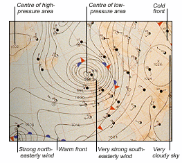 |
| Weather map From "Ultimate Visual Dictionary of Science," Stoddart 1998. |
Lines with bumps and/or spike-type symbols indicate where the air masses meet, which indicates where storms are occurring.
The bumps represent warm fronts and the spikes (or triangles) represent cold fronts.
One of the other major symbols shows wind direction as reported from various weather stations. These weather stations are indicated by a dot.
A 'key' shape joined to the dot indicates the wind direction. The direction of the key is the direction from which the wind is blowing.